Cartography
When I was five years old, I created fantasy world maps. In retrospect, my immediate family can probably take the credit (or blame). Everyone in my family was born somewhere else in the world, and as a young child, these places were magical with their exotic names conjuring up incredible images in my mind. I would search in vain through our family atlas, trying to locate these places I could barely pronounce, never mind spell. Maps became sources of wonder and enchantment, and my love for them grew. I am extremely fortunate that my work involves my passion. To date, I have created hundreds of maps for many clients. I have created maps for board games, stock market promotion (in print, and on promotional CD/DVDs), historical and fantasy maps in books, magazines, brochures, and a lot more.
• Click on the below images to enlarge •
|
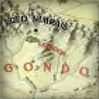
Lord of the Rings Map. Iron Crown Publishing approached me to create their Middle Earth map. This was a folded, insert map for an upcoming Middle Earth book publication. This map was published as an full colour 22x32-Inch map. I created the base art, while Iron Crown added the text and the colour of the large bodies of water.
|
|
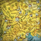
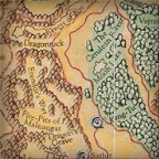
Mythic Europe Map. I was approached by White Wolf Publishing to create an insert map for their Mythic Europe book. They only had a small budget for a 11x17-Inch map so I suggested that I render the map as a single piece of artwork by hand rendering all of the art including the type. The base map was coloured using watercolours on paper.
|
|
Castle Falkenstein Map. I was approached by R. Talsorian Games who needed an insert map in their upcoming book. This was a commission for an 11x17-Inch map. I created the base art, including the border art with the four illustrations of various ships of the period including a flying machine, all set to a Steampunk setting of around 1880 AD.
|
|
Wild Wild West Map. The publisher, R. Talsorian Games, needed a insert map in their book and asked me to base it on the Castle Falkenstein map (see above), which I had previously created for them. This was an 11x17-Inch map. I created the base art and the border art with the four corner illustrations of, all set to a Steampunk setting of around 1880 AD.
|
|
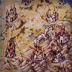
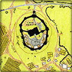
Heroth Castle. I have created hundreds of full color maps for various publishers over the years. The Heroth Castle mapping project is one such map. Having worked in field archaeology/site surveying/, as well as logging, I have a good understanding of how the land influences human habitation, and how humans change their environment.
|
|
Talislanta Map. This map was commissioned by Wizards of the Coast. The border art/logo was done in-house at WotC. This map was published as an full colour 22x32-Inch map.
|
|
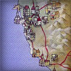
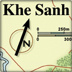
Khe Sanh. The Khe Sanh region, Vietnam, 1968. Over an eight year period I created many full color maps for Against the Odds Magazine. In many instances, I was needed to create a series of two or three maps showing troop positions and movements during various battles and campaigns including overall strategy maps.
|
|
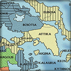
Map of Ancient Greece. This is the sort of typical detail that I like to see and create in my mapping work. This was commissioned and published by Against the Odds Magazine.
|
|
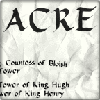
Map of the Siege of Acre, 1291 AD. This was just one of many small tonal/greyscale historical maps I created for various game and historical book publishers. This type of project is always fun to create. I created well over 100 such maps for various publishers over the years. This was commissioned by White Wolf Publishing.
|
HOME • BLACK INK PRINTS • COLORED PRINTS • PEN & INK • NATURAL HISTORY • CHILDREN'S ART • PAINT NITE • BIOGRAPHY • CONTACT • LINKS